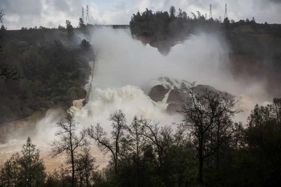
Engineers Have Known For Decades That Oroville’s Backup Spillway Would Fail
February 14, 2017
IMAGE: 65,000 cfs of water flow through a damaged spillway on the Oroville Dam in Oroville, California. REUTERS/Max Whittaker

IMAGE: 65,000 cfs of water flow through a damaged spillway on the Oroville Dam in Oroville, California. REUTERS/Max Whittaker
By Alex Dobuzinskis
Torrential rains in Texas which caused flooding that killed 16 people this week have spread to southern Louisiana, leaving parts of that state and Mississippi under a flash flood watch through Sunday morning, according to the National Weather Service.
Heavy rains could strike the Florida panhandle early next week, but not as intensely as in Texas, Daniel Petersen, a meteorologist at the Weather Prediction Center in Maryland, said in a phone interview on Saturday.
Small streams in southern Louisiana have overflowed their banks, causing localized flooding, he added.
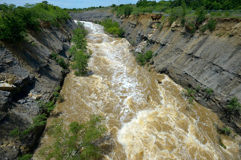
At least 16 people have died in Texas in the past week as some rivers swelled to levels not seen in more than 100 years, forcing thousands of people to evacuate their homes in low-lying areas.
Texas Governor Greg Abbott has declared a state of disaster in more than 30 counties, the Texas Department of Public Safety said in a statement on Saturday. In Bastrop County, southwest of the state capital of Austin, flooding damaged nearly 300 homes, it added.
Heavy rainfall was forecast to continue on Saturday along the Texas coast and potentially trigger more flooding there, state and federal officials said.
National Weather Service hydrologist Gregory Waller said in a phone interview on Saturday that the Brazos River was expected to crest this weekend near Rosharon, a community south of Houston that is home to more than 1,500 people.
The Texas Department of Criminal Justice began evacuating on Friday about 1,700 inmates at its Ramsey Unit in Rosharon, due to flooding along the Brazos.
Flooding struck Richmond, upriver from Rosharon, earlier this week when the Brazos overflowed its banks and according to state officials damaged nearly 80 homes.
Forecasters said that on Sunday the threat of flash floods in Texas would decrease as rains become less intense.
“We think that tomorrow, the lower rain totals are going to give them a chance to dry out,” Petersen said.
Even after the rains stop, parts of the state are likely to have a challenging path to recovery.
Gov. Abbott on Friday toured flooded areas south of Houston and told reporters some neighborhoods were “literally islands, completely surrounded by water.”
Nine soldiers died on Thursday when their troop carrier overturned during a training exercise at the U.S. Army base of Food Hood in the central part of the state, in a region where torrential rains caused flash flooding.
(Reporting by Alex Dobuzinskis in Los Angeles; Editing by Richard Chang)
Photo: An alligator crosses Sawmill Road near Brazos Bend State Park in flood waters in Fort Bend County after heavy rainfall caused the Brazos River to surge to its highest level causing flooding outside Houston, Texas, in this picture taken June 1, 2016, courtesy of the Fort Bend County Sheriff’s Office. Fort Bend County Sheriff’s Office/Handout via REUTERS
By Matt Pearce, Los Angeles Times (TNS)
It finally stopped raining this week in Oklahoma and Texas, where a nearly nonstop series of storms resulted in deadly flooding and made for the wettest month in both states’ recorded history.
So what is happening to all that water?
Some of it, naturally, will evaporate. Some has replenished reservoirs in both states after a punishing five-year drought.
But like the end of a football game when everyone heads for the exits, the waters are inundating rivers across four states, bringing new flood worries for weeks ahead as the torrents barrel toward the Gulf of Mexico.
Water from Oklahoma will first head through rivers in Arkansas and Louisiana before reaching the gulf. The water in eastern and southern Texas will generally take more direct paths to the coast.
“It’s a giant web,” Brannen Parrish, spokesman for the Tulsa, Oklahoma, district of the U.S. Army Corps of Engineers, said of the river system running through the lower Plains. “Ultimately that water ends up in the Gulf of Mexico.”
The rains in Texas and Oklahoma brought both sorrow and blessing — floods that claimed hundreds of homes and killed at least 36 people, but also ended a devastating drought.
A year ago, Texas’ reservoirs were only at 67 percent capacity, according to state water data. But in the last three months, capacity has jumped to 83 percent after reservoirs trapped enough rain to cover nearly 23,000 square miles of land — almost one-tenth of Texas — with about a foot of water. Some reservoirs in western Texas, not as hard hit by the storms, were still running low this week.
But in Oklahoma, almost every one of the state’s dozens of reservoirs has exceeded 100 percent normal capacity.
“The fact that we were in a drought helped mitigate some of the flooding issues we would have seen had they not had that extra space available,” said James Paul, a hydrologist for the National Weather Service’s Arkansas-Red Basin River Forecast Center.
However, Paul added, “once they get to the point of being as full as they can get, they have to start releasing that water.”
Many rivers in the region have grown dramatically more powerful because of the surging runoff.
About this time of year, the Red River typically passes between 8,000 and 15,000 cubic feet of water per second where it forms part of the border between Texas and Oklahoma, Paul said.
After last month’s deluge, the Red River has grown more than 10 times in volume and was pumping nearly 235,000 cubic feet of water per second downriver toward Arkansas and Louisiana as of Monday, he said.
“All that water in Oklahoma and northeast Texas that drains into the Red River is making its way to us,” said Aaron Stevens, the observing program leader at the National Weather Service’s office in Shreveport, La., noting that the region has already been deluged. “All the crops that have been planted in the lowlands have flooded, and we’ve lost those crops, and we have a lot of cattle that feed in those lowland areas.”
The Red River is expected to rise about 2 feet by Saturday as it passes through Shreveport in northwest Louisiana. Inmates in Caddo Parish, which includes Shreveport, have helped prepare sandbags for the river’s inevitable attack on the low-lying areas.
“We are not expecting any flooding inside residences, but there will be street flooding, if they aren’t experiencing that already,” Sheriff Steve Prator said in a statement Tuesday, warning the parish’s residents to be prepared. “We know our citizens are keeping a close eye on how the flood may affect their neighborhoods, and we want to make sure they are prepared for all possibilities.”
The Red River eventually dumps into the Atchafalaya River in east-central Louisiana, which then empties into the Gulf of Mexico.
The Arkansas River — which runs through Oklahoma and Arkansas until it flows into the Mississippi River — has also picked up strength, expanding from an average of about 50,000 cubic feet of water per second to roughly 300,000 to 350,000 cubic feet per second, according to Paul.
More than 40 homes have already been flooded downriver in Jefferson County in central Arkansas, where part of the courthouse and county facilities were swept away by the Arkansas River during a 1908 flood.
Some residents are taking boats to and from their homes and have put furniture, clothes and pictures on their roofs to prevent them from getting wet, Maj. Lafayette Woods of the Jefferson County Sheriff’s Office said Tuesday.
Rains and river surges from Oklahoma have “not been good for us,” Woods said in an earlier interview, adding that the water had lapped over some sandbags protecting low-lying homes.
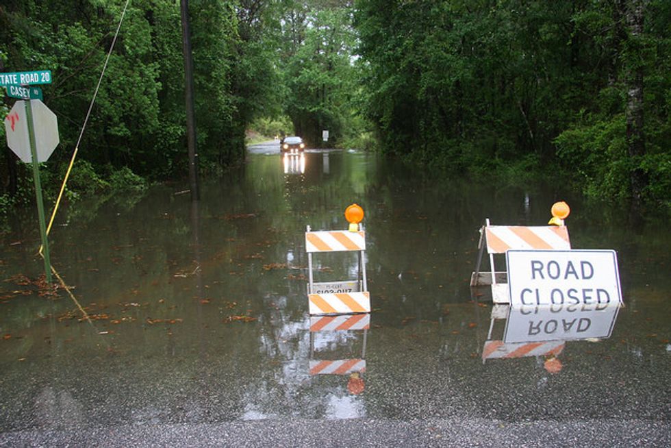
In Texas, the Nueces River will remain at major flood stage northwest of Corpus Christi through at least the rest of this week. The Trinity River, which is expected to flood for weeks, neared a record high southeast of Dallas on Tuesday before beginning to decline.
Both rivers, which flow through Texas before dumping into the gulf, are projected to threaten some homes and river farmland but have a generally beneficial effect on the environment.
“For river systems, these sort of flood events are a natural part of the landscape that resets the systems in many respects,” said Thomas Hardy, who studies rivers and river ecosystems at the Meadows Center for Water and the Environment at Texas State University.
The new freshwater flows after years of drought will also be welcome for wildlife at bay and estuary systems along the coast, Hardy said.
Meanwhile, recovery continues in Hays County, Texas, where at least eight bodies have been found and three people remain missing after the Blanco River overflowed. On Tuesday, county officials said the last unidentified body discovered in the county belonged to Kenneth Reissig, 81, whose remains had been found May 28.
Officials say downriver flooding would be even worse if it weren’t for flood-control infrastructure built several decades ago as part of a long-running struggle between the government and the nation’s unruly rivers.
“It’d be a catastrophe” if an extensive system of levees and reservoirs weren’t keeping the waters in check, said Greg Raimondo, a spokesman for the Vicksburg, Mississippi, office of the Army Corps of Engineers. “There’s a lot of flat ground out there, you know?”
(c)2015 Los Angeles Times. Distributed by Tribune Content Agency, LLC.
Photo: Flood waters being released from Lake Bridgeport in Bridgeport, Texas, on Monday, June 1, 2015. Tarrant Regional Water District officials now say the West Fork of the Trinity has grown to three quarters of a mile wide around Boyd. The flows haven’t peaked yet and may not for several days. (Max Faulkner/Fort Worth Star-Telegram/TNS)
Washington (AFP) — Many U.S. coastal communities already struggle with flooding at high tides, a problem that will become “chronic” in the coming 15 years due to global warming, scientists said Wednesday.
As shorelines are growing more populated, sea levels are swelling due to melting glaciers and polar ice sheets, putting more populations at risk, said a report by the Union of Concerned Scientists.
Particularly dire consequences are expected along the U.S. east coast and the Gulf Coast, the report warned.
“Our analysis shows that increases in tidal flooding will be substantial and nearly universal,” said the report, based on tidal gauges in 52 coastal communities from the northeastern state of Maine down to Florida and along the Gulf Coast of Texas.
“That means the steady creep of sea level rise will force many communities largely unfamiliar with tidal floods today to grapple with chronic flooding in the next 15 to 30 years.”
Scientists said the floods, while not catastrophic, could harm key infrastructure such as bridges and roads and cause property damage.
From 1880 to 2009, global sea levels rose about eight inches (20 centimeters). Today, oceans are rising at an even faster rate.
“No longer an intangible global trend, sea level rise has arrived on the doorstep of communities scattered up and down the east coast, delivered by the tides,” it added.
“In the next 15 years alone, two-thirds of these communities could see a tripling or more in the number of high-tide floods each year.”
– Big changes in mid-Atlantic –
The biggest changes are expected in the mid-Atlantic, said the report.
The U.S. capital, Washington, DC, and Annapolis, Maryland can expect more than 150 tidal floods per year by 2030.
In southeastern towns like Savannah, Georgia and Lewisetta, Virginia, “extensive flooding is expected to occur with tides alone on a regular basis within one or two decades,” said the report.
“By 2045, even more places can expect to see extensive flooding, including Ocean City, Maryland, and Myrtle Beach, South Carolina.”
In some places, the changes may be dramatic. For instance, the northeastern town of New London, Connecticut currently experiences tidal floods about twice per year, but that could rise to 35 in 30 years.
Spots along Texas’s Gulf Coast that rarely see tidal floods “could face 35 to 70 tidal floods per year by 2045,” the report found.
Some places, like Norfolk, Virginia, have put up tide gates to keep floods out of downtown business districts, but that’s not an option everywhere.
Miami, the world’s seventh richest city, is built on porous limestone and is already losing water wells to incoming saltwater. The city of 417,000 faces more frequent flooding of business and residential areas.
“By 2030, Miami can expect the frequency of tidal flooding to increase nearly eightfold — from about six per year today to more than 45,” said the report.
“And by 2045, the city can expect more than 40 times as many floods as today.”
New Jersey’s coastal resort towns and gambling haven of Atlantic City — which were battered by Superstorm Sandy in 2012 — are also forecast to see floods up to 90 times a year by 2030, and 240 annually by 2045.
“Such unrelenting disruption could radically change the South Jersey Shore as a place to live and play,” said the report.
– ‘Dangerous’ climate change –
The problem is not new, and some east coast communities have already seen “a fourfold increase in the annual number of days with tidal flooding since 1970,” it found.
Solutions adopted by some coastal communities involve a combination of defending against the rising waters, accommodating them or retreating from them.
The report urged world leaders to take the threats seriously and plan ahead, but also to cut back on burning fossil fuels that lead to global warming.
“Global emissions are rising rapidly, and are on a trajectory to push surface temperatures more than 2 Celsius (3.6 Fahrenheit) above the pre-industrial average — the threshold beyond which scientists say ‘dangerous’ climate change becomes unavoidable,” said the report.
“To stay below this threshold, and slow the rate of sea level rise later this century and beyond, global carbon emissions need to peak and begin to decline by the end of this decade.”
Photo via Florida Fish and Wildlife via Flickr
Interested in more national news? Sign up for our daily email newsletter!
The National Memo is a political newsletter and website that combines the spirit of investigative journalism with new technology and ideas. We cover campaigns, elections, the White House, Congress, and the world with a fresh outlook. Our own journalism — as well as our selections of the smartest stories available every day — reflects a clear and strong perspective, without the kind of propaganda, ultra-partisanship and overwrought ideology that burden so much of our political discourse.