Schools Get Tested On Their Earthquake Safety, With Kids’ Help

Schools Get Tested On Their Earthquake Safety, With Kids’ Help

By Sandi Doughton, The Seattle Times (TNS)

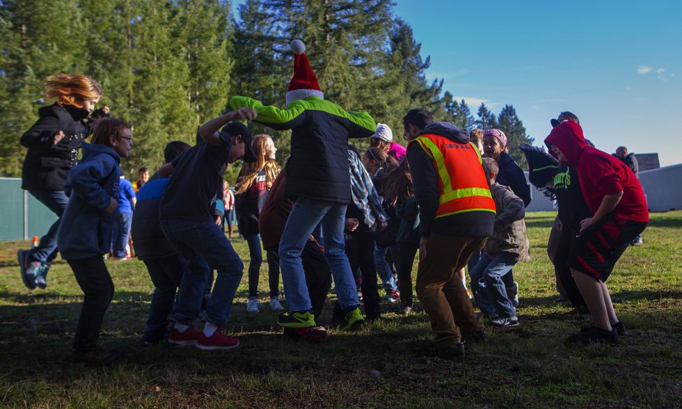
YELM, Wash. — On the count of three, a scrum of six-graders flung themselves in the air, landing with a thud that vibrated the ground under their feet.

Nearby, their classmates huddled around a computer, watching jagged tracings scroll across the screen as sensors picked up shaking from the mini-earthquake at Lackamas Elementary School last week.

Surrounded by boisterous 11- and 12-year-olds, geologist Recep Cakir explained that he and his crew are measuring the way seismic waves move through the soil to estimate how hard the ground will shake in future earthquakes.

The work is part of a pilot project, which also includes building inspections, to determine how well several Thurston County schools will stand up to a major quake.

With a $45,000 grant from the Federal Emergency Management Agency and volunteer assistance from structural engineers, the project is evaluating the seismic safety of 15 schools in three districts. But the bigger goal is to develop a standard process that could be applied to schools across the state, said John Schelling, of Washington’s Emergency Management Division.

“The time is right to look at the state of the science and really assess how vulnerable one of our most precious assets is — our kids,” he said.

Over the past 25 years, scientists have discovered that the Pacific Northwest is subject to megaquakes and tsunamis from the offshore fault called the Cascadia Subduction Zone, as well as powerful, shallow quakes on faults under Seattle, Everett, Tacoma and other cities.

But many of the state’s schools predate modern building codes that take those hazards into account.

Using a FEMA model and an estimate of the mix of building types across the state, the Office of the Superintendent of Public Instruction calculated a magnitude-9 Cascadia quake could hypothetically cause more than $4 billion in damages and loss of services at school facilities, kill 117 students and staff and injure more than 3,000.

A similar analysis by FEMA estimates half the schools in Washington’s I-5 corridor would suffer medium to high damage.

But no one knows really knows how widespread the risk is — or which schools are in the greatest peril.

“Washington is really the only state on the West Coast that hasn’t completed a detailed, comprehensive assessment of all school facilities,” Schelling said.

California first started evaluating and upgrading schools in the 1930s. British Columbia made seismic safety a priority a decade ago, and has spent $2.2 billion to strengthen high-risk schools.

Earlier this year, Oregon’s state Legislature earmarked $300 million to retrofit schools and other critical facilities, spurred by a survey that found 1,100 school buildings potentially at a high or very high risk of collapse in a major quake.

“I think it’s pretty safe to say it’s a similar story in Washington,” said Cale Ash of Degenkolb Engineers, who’s helping coordinate the pilot project and donating time to inspect school buildings. “The two states have similar ages of construction.”

In Washington, the seismic safety of schools is primarily the province of school districts. Thanks to voter-approved levies, Seattle has retrofitted the majority of its older school buildings and several projects are in the works. But in less-affluent districts like Aberdeen, where a previous survey identified seven schools and administrative facilities at high risk of collapse, there’s little money to pay for upgrades.

Many districts haven’t evaluated the seismic safety of their schools. The state Legislature also failed to act on recommendations from the Washington State Seismic Safety Committee to fund a statewide survey.

OSPI recently analyzed earthquake, flood and other natural hazards confronting schools across the state. Among its findings is that 32 schools and school facilities sit in the likely path of a Cascadia tsunami. But only 25 of the state’s 295 school districts have signed on for more-detailed analysis of the threats they face.

“It’s important to get a baseline assessment of where we are statewide, so we can understand how pervasive the problems are and give districts good information so they can set priorities,” Schelling said.

During the pilot project in Thurston County, engineers are inspecting each school, looking for structural weaknesses and hazards like bookshelves that aren’t bolted to the wall. Those observations will be combined with the data Cakir and his team are gathering on how solid — or shaky — the ground is at each site.

A report on the pilot project, which covers schools in the Yelm, North Thurston and Tumwater school districts, is expected in February.

Expanding the survey program across the state would cost about $13 million and take about eight years, said Tim Walsh, chief hazards geologist for the Washington Department of Natural Resources. The agency also employs Cakir and his team, and is overseeing their seismic surveys.

©2015 The Seattle Times. Distributed by Tribune Content Agency, LLC.

Photo: Sixth-grade students at Lackamas Elementary School in Yelm, Wash., recently helped researchers measure the way seismic waves move through soil by literally jumping into the work. (Ellen M. Banner/Seattle Times/TNS)

Paul Allen Gives $100 Million To Explore How Cells Work

Paul Allen Gives $100 Million To Explore How Cells Work

By Sandi Doughton, The Seattle Times (TNS)

SEATTLE — After tackling the brain, the Ebola epidemic, and a host of other issues, billionaire Paul Allen has a new target for scientific philanthropy: unraveling the inner workings of human cells.

On Monday, the Microsoft co-founder announced a $100 million, five-year grant to establish the Allen Institute for Cell Science in Seattle.

The goal is to better understand the teeming world inside cells, where thousands of organelles and millions of molecules interact in a dynamic ballet that researchers are just beginning to fathom.

“We really don’t have a good idea of how normal cells work, and what goes wrong in disease,” said Rick Horwitz, the former University of Virginia professor who jumped at the chance to lead the new institute. “People spend careers trying to understand little parts of the cell, but nobody has stitched it together — because it’s too complicated for any individual to study.”

The institute will take on the challenge by combining new technologies, like microscopes that can visualize living cells in three dimensions, with enough computational firepower to make sense of the flood of data that will result, Horwitz said.

Eventually, he and his team hope to develop computer models that mimic living cells. If they succeed, those models could also shed light on what goes haywire in cancer and other diseases and help develop cures, he said.

At a time when federal research budgets are shrinking, the announcement is “one of the most exciting things to happen in Seattle science in a long time,” said Dr. Chuck Murry, co-director of the Institute for Stem Cell and Regenerative Medicine at the University of Washington. “When the Allen folks get into something, they do it at a scale that’s just mind-blowing.”

The grant is one of Allen’s largest, on par with the $100 million he committed earlier this year to fight Ebola in West Africa, and a $100 million grant in 2003 to establish the Seattle-based Allen Institute for Brain Science. He has since plowed an additional $300 million into the brain institute.

Allen, who joined his old partner Bill Gates in pledging to donate the bulk of his wealth, has stepped up his philanthropic efforts in recent years. It’s a good bet he will continue investing in the cell institute — as long as it measures up, said Allan Jones, who leads the Allen Institute for Brain Science and helped organize its new sister institute.

“We need to knuckle down and show that we can deliver something very powerful,” Jones said.

Diagrams in biology textbooks make it seem like cell structure and function have already been nailed down. Scientists have, indeed, learned a lot about different cell types, the role of organelles like the nucleus, and specific pathways, like the chain of events that causes muscle cells to contract. But there’s a big gap when it comes to understanding the way cells function as a whole.

For example, researchers tried for years to coax breast tissue cells growing in petri dishes to produce milk proteins with no success. What finally worked was growing the cells on a pliable matrix, more like their natural habitat.

“All these nuances are really important,” Horwitz said.

One reason it has proved so difficult to translate genetic discoveries into treatments is that scientists have only a fuzzy idea of the way gene mutations upset the normal cellular machinery.

Applied on a large scale, super-resolution microscopy along with techniques to precisely tweak DNA and tag molecules with fluorescent dyes will allow researchers at the institute to track what’s happening inside normal cells and see what changes when mutations are introduced, Horwitz said.

The result will be like Google Maps for cells, he added. “Our output will be a kind of visual, dynamic atlas that shows where all of these things are in the cell and how they change over time.”

The first project will focus on the way stem cells derived from adult tissue transform themselves into multiple cell types, including heart muscle and skin.

Understanding that process in more detail will be of great value in the effort to harness stem cells to repair damaged organs ,said Jennifer Lippincott-Schwartz, president of the American Society of Cell Biology.

Horwitz and Jones unveiled plans for the institute Monday at the society’s annual meeting in Philadelphia.

“We’re all very excited about this initiative,” Lippincott-Schwartz said.

With its dedicated mission, the cell institute will be able to bring together experts in cell biology, computational modeling and microscopy in a way that’s tough to do at a university, said Joan Brugge, chair of the Department of Cell Biology at Harvard Medical School.

“You need a really coordinated effort,” said Brugge, who serves on the institute’s science advisory board. “It’s very difficult for the federal funding agencies to fund these kind of Manhattan Project-style initiatives, because they are so large.”

Just as at the Allen Institute for Brain Science, all of the data and tools developed at the cell institute will be freely available to scientists around the world.

The two institutes will be housed together in a new, seven-story lab building under construction in the South Lake Union neighborhood.

The cell institute will employ about 75 scientists, technicians and other staff, Horwitz estimated.

Photo via Wikimedia Commons

Fighting Addiction With Another Drug

Fighting Addiction With Another Drug

By Sandi Doughton, The Seattle Times (TNS)

SEATTLE — Amber Mellen was a newlywed when her soldier husband was killed in Iraq. Just 18 years old, she turned to pain pills to dull the grief.

But Mellen got hooked on the drugs and spiraled into addiction. Before long, she was shooting up heroin.

“It was so easy to get, and so many people are doing it,” she said. “People who you see in the grocery store, people you would never expect are using it.”

New data from the University of Washington show that heroin use among young adults in Washington state is soaring, particularly in rural and suburban areas where treatment and counseling can be hard to find.

Last year, heroin was the leading reason people ages 18 to 29 sought treatment for substance abuse, far surpassing admissions for alcohol, methamphetamine or prescription drugs. The number of young people admitted for heroin treatment has more than quadrupled since 2007.

Experts believe many drug users are turning to heroin because recent rules have made it harder to get prescription painkillers like oxycodone. Drug cartels have rushed to fill the gap with Mexican black tar and other forms of heroin, which can sell for as little as $20 a dose.

Yet many doctors remain reluctant to prescribe a medication that can help some patients overcome addiction without having to travel to a methadone clinic every day.

Buprenorphine, marketed under the name Suboxone, is available for addiction treatment. But an analysis published this year found that fewer than a third of certified physicians surveyed were giving patients the drug.

Many doctors who don’t prescribe buprenorphine said they were wary of working with addicts without a more robust system of counseling and social assistance.

“It’s really a crisis,” said Dr. Roger Rosenblatt, an author of the study and associate director of the University of Washington’s Rural/Underserved Opportunities Program. “People are suffering, people are dying, and we have the therapy for it.”

Only 10 to 20 percent of people who need some form of addiction treatment are getting it, said Dr. Charissa Fotinos, deputy chief medical officer for the Washington State Health Care Authority.

Like methadone, “bupe,” as it is sometimes called, blocks symptoms of withdrawal and craving, and it helps users avoid the temptation to relapse. The risk of overdosing on bupe is much lower than on methadone. And while methadone must be administered at a clinic, buprenorphine can be prescribed for use at home.

That’s particularly helpful for young adults, who may be facing years of treatment while juggling school, work and families, said Caleb Banta-Green of the university’s Alcohol and Drug Abuse Institute. Rural residents also can benefit significantly, because most of the state’s methadone clinics are in urban areas.

“Getting to a methadone clinic every day can be a pain in the butt for a lot of people,” he said.

By the time Mellen decided to seek treatment, she had been shooting up for three years. “I was the worst of the worst,” she said. “At the end, I was on the street.”

She tried methadone, but it put her into a stupor. Suboxone eased the gnawing desire for heroin, and helped clear her head.

“It made me myself again,” she said.

Now 26, Mellen has been on the medication for two years. She gets it from Dr. Lucinda Grande, a primary-care physician in Olympia. With a long-standing interest in chronic pain and drug abuse, Grande was eager to take the eight-hour class required of doctors who want to prescribe buprenorphine for addiction.

Grande often has to turn patients away. “I just feel so guilty because somebody might be a good candidate, and they really need this drug, but I can’t take them.”

The Affordable Care Act requires Medicaid and most private insurance to cover substance-abuse treatment. That includes buprenorphine, which can cost $300 a month or more.

But many physicians don’t want to work with addicts or add a new type of treatment to their already-busy practices. None of Grande’s five partners at Pioneer Family Practice decided to prescribe buprenorphine.

“It’s a very demanding group of patients,” said Dr. Edward Cates, one of those partners. He also worries that the benefits of the medication have been exaggerated.

Clinical trials show that buprenorphine is slightly less effective than methadone in eliminating opioid abuse. Like methadone, it can also be dangerous.

The drug is an opioid and can generate a high in people who aren’t regular users. It has become part of the illegal drug market — diverted by unscrupulous patients and purchased by recreational drug users and addicts who can’t get a prescription. Buprenorphine has also been linked to several hundred overdose deaths nationwide. In most cases, though, the victims had ingested several different drugs.

“I’m not trying to undersell its risks,” Banta-Green said. “But I personally don’t have any doubts that the benefits outweigh the risks.”

Addiction is a chronic, relapsing condition, and many people have to go through multiple cycles of treatment before it sticks, Banta-Green said. But decades of studies show that maintenance medication, like methadone and buprenorphine, is the most powerful tool available to help users stay off heroin and related drugs.

Meanwhile, health experts also hope to raise awareness of an antidote that could reduce the number of overdose deaths in the state if administered quickly.

Naloxone, sold under the trade name Narcan, can save people who take too much heroin, methadone or prescription pain pills.

Some ambulance crews carry the drug, and several pharmacies around the state stock a nasal-spray version. It’s available without a doctor’s visit to opiate users and their friends and families.

AFP Photo/Andrew Burton

NIH Director Says U.S. Likely To Spend A Billion On Ebola Fight In Coming Months

NIH Director Says U.S. Likely To Spend A Billion On Ebola Fight In Coming Months

By Sandi Doughton, The Seattle Times

SEATTLE — Over the next few months, the United States will probably spend a billion dollars responding to the Ebola outbreak in West Africa, the director of the National Institutes of Health said in Seattle on Wednesday.

Factor in the amount being invested by other nations, and “it’s going to be an enormous number,” Dr. Francis Collins said at a Gates Foundation conference.

But much of that expense could have been avoided had the U.S. and others provided adequate funding to push forward the development of Ebola vaccines and drugs that have been languishing for years, Collins said.

“If one wants to be prepared, it costs money to do so,” he said. “We have been shortchanging that for the past decade, at least in the U.S.”

Collins was part of a panel on Ebola added to an event commemorating the Bill & Melinda Gates Foundation’s Grand Challenges program of innovative health research. The foundation has pledged $50 million to help fight the Ebola epidemic, in which nearly 3,900 people have died and more than 8,000 have been sickened across Liberia, Sierra Leone and Guinea.

While much of that money is going to bolster the on-the-ground response, the foundation is also working to accelerate progress on treatments and vaccines, said Chris Karp, vaccine-team leader for the philanthropy.

Gates is funding efforts to step up production of ZMapp, a promising drug that protected monkeys from Ebola even days after the animals were infected. The drug was administered to a handful of people infected recently, including two American aid workers. They survived, but others who got the drug did not — so it’s still unclear how well it works in humans.

But the current method of producing the drug in tobacco plants is slow, Karp said. Gates provided money to explore large-scale production methods.

The foundation is also funding work on the use of the immune-booster immunoglobulin as a treatment for Ebola, and on methods to isolate and mass produce antibodies that target the virus, including antibodies from people who survived infection.

The World Health Organization is fast-tracking preliminary human trials on two promising vaccines, compressing a process that normally takes four to five years into a few months, said WHO’s Vasee Moorthy.

In collaboration with the British charity Wellcome Trust, the Gates Foundation is assisting in that effort, too, paying for production of the vaccine used in the trials.

An audience member asked why the pharmaceutical giant GlaxoSmithKline, which owns one of the vaccines, doesn’t pay for the production itself so the charities could spend more of their money in the affected countries.

David Vaughn, the GlaxoSmithKline representative on the panel, sidestepped the question, pointing out the need for multiple partners to fund such an ambitious endeavor.

Vaughn said nine trials could be under way before the end of this year. GlaxoSmithKline is also exploring the unprecedented step of conducting preliminary and advanced trials simultaneously, to more quickly determine if the vaccine is safe and effective.

A British expert who has been modeling the spread of Ebola, said he doubts the drugs or vaccines will be ready in time to have much impact on the current outbreak. The way to bring the virus under control is through the standard tools of public health, such as isolating infected people and tracing their contacts, said Neil Ferguson, of Imperial College, London.

But in countries with threadbare health systems, even those basic measures have been difficult.

The epidemic appears to have leveled off in Guinea, where it was detected early, Ferguson said. But in Sierra Leone, where there was virtually no system to spot and track infections, it continues to build.

The one technological tool that could make a difference now would be a quick way to diagnose the disease, Ferguson added.

The Gates Foundation is working on that, too, Karp said. But, despite his affiliation with a tech-oriented organization, Karp agreed that the immediate answer isn’t new drugs or devices. “The fundamental barriers are not technical,” he said. “They’re systems. They’re resources.”

AFP Photo/Mike Stone

Changing Sea Chemistry Will Hit Alaska Communities Hard, Study Says

Changing Sea Chemistry Will Hit Alaska Communities Hard, Study Says

By Sandi Doughton, The Seattle Times

SEATTLE — Oyster growers in the Pacific Northwest have already been stung by changes in ocean chemistry linked to greenhouse-gas emissions.

Now, a new study led by Seattle researchers finds communities in Southwest and Southeast Alaska that rely on the sea for food and jobs are also likely to be hit hard over the coming decades.
The analysis, published this week in the journal Progress in Oceanography, is among the first to examine the potential social and economic impacts of ocean acidification — sometimes called global warming’s twin.

Just as carbon dioxide from power plants, factories, and cars diffuses into the atmosphere, the gas is also absorbed by the world’s oceans. As a result, scientists say the average pH of seawater has become slightly lower, or more acidic, since the start of the industrial era.

That effect is expected to intensify in the future — and some places are more vulnerable than others.

The Alaskan waters that yield much of the U.S. commercial-seafood catch are near the top of that list, said lead author Jeremy Mathis, of the National Oceanic and Atmospheric Administration’s Pacific Marine Environmental Lab in Seattle.

Carbon dioxide dissolves more readily in cold water, and the Bering Sea and Gulf of Alaska are already naturally CO2-rich.

“It doesn’t have that far to go before it reaches this critical threshold where the water can become corrosive,” Mathis said.

That’s what scientists say occurred along the Washington and Oregon coasts beginning in the mid-2000s. Naturally low pH levels dropped even further, killing oyster larvae in hatcheries that drew water from the Pacific.

The industry solved the problem by closing intake valves when pH is low, but some companies also shifted operations to Hawaii.

Many Alaskan communities, where people live off the seafood they catch, don’t enjoy that flexibility, Mathis said. If crab or salmon populations crash, people will see their main source of protein, and economic well being, diminish.

In identifying the most vulnerable communities, the researchers examined incomes, educational levels, educational opportunities, and job diversity.

They also looked at which seafood species dominate local economies and diets, and how those species are likely to be affected by changing ocean chemistry.

Red king crab, for example, appear to be very sensitive to small changes in acidity that can make it harder to build shells. In laboratory tests, larvae died at a high rate when exposed to pH levels that now occur some times of the year in the Bering Sea.

By 2100, those conditions are expected to be common. “The waters of the Gulf of Alaska and the Bering Sea and the Arctic Ocean will be corrosive to shellfish throughout the year,” Mathis said.

Salmon are less sensitive to pH, but are still at risk because of possible effects on their food. Tiny creatures called pteropods, which are eaten by a wide range of fish, are already being harmed by water corrosive to their shells along the West Coast and other places.

Many of these problems were detailed last year in a series of stories by The Seattle Times.

Drawing on existing studies of the impacts of changing pH on marine creatures, the researchers used computer models to estimate potential impacts on harvests by the year 2100. In some places, like Dillingham on Bristol Bay, they found some catches could drop by as much as 70 percent.

But Tuesday’s study contains few numbers, and no estimates of potential economic impacts. That’s because there are so many unknowns, said co-author Steve Colt, professor of economics at the University of Alaska Anchorage.

“We just don’t know enough about all the links in the chain, starting with the ocean chemistry and going through the various levels of the food chain and even getting from potential changes in fish abundance and distribution to the economic impact to communities,” he said.

Instead, the researchers calculated a relative risk index. Communities most at risk are colored red on a map — and are concentrated in the southeast and southwest portions of the state.

For example, Petersburg, an island community in Southeast Alaska where many Washington-based fishing boats operate, ranks high in the red category because it is so dependent on seafood and has few other job opportunities.

Even without hard figures, the study is one of the first attempts to bridge the gap between scientific research on ocean acidification and its potential impacts to people, said Scott Doney, chairman of the Marine Chemistry and Geochemistry Department at Woods Hole Oceanographic Institution in Massachusetts.

“This brings it home to the level of talking to community leaders, political leaders and business leaders in Alaska to say here are the areas we think are the most vulnerable,” said Doney, who was not involved in the project.

Photo: Svadilfari via Flickr

Interested in national news? Sign up for our daily email newsletter!

Experts Hope Tragedy Spurs National Efforts To Reduce Risk From Landslides

Experts Hope Tragedy Spurs National Efforts To Reduce Risk From Landslides

By Sandi Doughton, The Seattle Times

SEATTLE — Ten years ago, a panel of leading scientists called for a comprehensive, national program to reduce the risk from landslides — but the plan was never funded.

Now, experts are wondering whether the tragedy at Oso, Wash., will revitalize efforts to assess landslide hazards, communicate them to the public and help local communities improve land-use planning.

“I think there’s a chance,” said Peter Lyttle, landslide-program coordinator for the U.S. Geological Survey (USGS). “As in so many of these awful cases, it’s a teachable moment.”

But even the deaths of more than 40 people may not be enough to shift national priorities, said University of Washington political scientist Peter May, who served on the National Research Council (NRC) committee that authored the report in 2004.

“It might lead to innovative ways to use existing funds, but I don’t think it will lead to the creation of a serious, national program,” he said.

There has never been a groundswell of public support for efforts to lower the risk from landslides, May pointed out. And because slides strike sporadically and are usually isolated events, they rarely rise to the top of the list when politicians are drawing up budgets.

“It’s a difficult problem,” May said. “It’s only in the aftermath of events like Oso that alarm bells go off and people say, ‘Maybe we better do something about it.’ ”

The NRC committee recommended a $365 million, 10-year program coordinated by the USGS, with much of the money passed on to states. But actual funding for USGS’ landslide work has averaged less than a tenth of that amount over the past decade.

After several major landslides in the late 1990s, including one in La Conchita, Calif., that destroyed 14 houses, the USGS mapped out an ambitious landslide program at the direction of Congress. Based on data from the 1980s, the agency estimated 25 to 50 people are killed every year by landslides in the United States, with property damage exceeding $2 billion.

But those numbers are outdated, said Lynn Highland, of the USGS National Landslide Information Center.

Better measurement of the economic and human toll from landslides was one element of the program proposed by the USGS and endorsed by the science panel in 2004. Others included scientific research on landslides and their triggers, maps of high-hazard areas, and monitoring of the most treacherous areas to provide warnings for communities in harm’s way.

The plan also called for outreach programs to ensure that information reaches people at risk from landslides and the local agencies that oversee land use and development.

“One thing that makes landslide hazards different from earthquakes or hurricanes or other types of natural hazards is that it tends to be dealt with at a local level,” Lyttle said. “There are lots of arguments in just about every community in the nation about whether to strictly zone or not.”

In some parts of the country, landslide-mapping programs have been discontinued because of the possible impact on property values, said Scott Burns, a landslide expert at Portland State University.

But plans are already in the works for a new landslide hazard map of Snohomish County, where the recent tragedy occurred, Lyttle said.

The question of a revitalized landslide program will also be on the agenda in June at the annual meeting of the American Association of State Geologists, Lyttle said.

USGS scientist Jonathan Godt met last week with staffers who work for Sen. Maria Cantwell and Rep. Suzan DelBene of Washington state, and Sen. Mark Udall of Colorado — which was hit by multiple landslides this past winter — to discuss possible ways to bolster landslide programs.

But money is tight, Lyttle said. “To carve out an increase for one program tends to mean that somebody has to find a place to cut.”

If nothing else, the Oso slide should spur mayors and other local elected officials to start asking questions about landslide safety, May said. “They should be talking about it and asking: ‘What are we doing? Should we be doing more?’ ”

Highland, of the National Landslide Information Center, is working on a pilot project to combine state landslide inventories as a small step toward a national inventory. But another project she planned to start this spring — to develop a new estimate of economic losses from landslides in Washington and Oregon — was canceled due to lack of funding.

Marcus Yam/Seattle Times/MCT

Expert Baffled By Ferocity, Distance Of ‘Freakish’ Landslide

Expert Baffled By Ferocity, Distance Of ‘Freakish’ Landslide

By Sandi Doughton, The Seattle Times

SEATTLE — Richard Iverson may be one of the world’s foremost landslide experts, but if he had been driving along the Stillaguamish River March 22 when the slope across from Steelhead Drive began to crumble, he wouldn’t have fled to high ground.

He would have pulled over to snap pictures.

That’s because Iverson never dreamed a slide from such a modest bluff could travel as far and as fast as it did, sweeping across the river, burying an entire neighborhood and engulfing a swath of Highway 530 in a minute’s time.

“It was a freakish thing,” said Iverson, of the U.S. Geological Survey’s Cascades Volcano Observatory. “I’m not sure anybody would have anticipated a slope like that would liquefy the way it did.”

Using a new computer model, Iverson estimated that the mass of mud, rocks and trees was traveling about 60 mph when it slammed into the river.

Imagine standing on the side of a freeway when a semi-truck barrels past at 60 mph, Iverson said. Then imagine a battalion of eighteen-wheelers, half a mile wide, headed straight at you.

“It’s hard for me to imagine somebody being in the middle of that Steelhead neighborhood and having any chance of survival,” he said.

Snohomish County officials have reported 35 people dead and an additional 10 missing.

An eyewitness Iverson spoke with described the slide literally shoving the river out of its banks.

Iverson spent several days at the site last week and is compiling the first scientific report on what he believes will be a “profoundly important” event in the understanding of landslide hazards.

When the recovery effort is over, he and other scientists hope to study the slide in detail, trying to figure out why it so quickly liquefied and ran out for nearly a mile — more than three times the distance Iverson would have expected based on comparison with hundreds of other slides of similar heights.

“This bluff is only about 180 meters (about 600 feet) tall, which by Northwest standards is sort of small potatoes,” Iverson said.

The hope is that by understanding what caused the slide to morph into a monster, scientists will be able to better identify the most dangerous hazard zones in the future, said Jonathan Godt, a Denver-based USGS expert who also visited the Oso slide.

“It’s one of these tragic events that unfortunately provides an opportunity to increase awareness,” he said.

While it’s fairly easy to identify landslide-prone slopes, it’s much harder to predict how far slides will travel, said University of Washington geomorphologist David Montgomery. Geologists who analyzed slide risks along the North Fork of the Stillaguamish warned in 1999 that a “large catastrophic failure” was possible. But in the worst-case scenario they deemed most likely, the runout was estimated at less than a quarter of a mile.

“Any geologist who went out there would say, yes, this situation is ripe for a landslide,” Iverson said. “But in my mind, the story isn’t that a landslide occurred, but the type of landslide that occurred.”

He blames the disaster on a combination of unusually wet weather, erosion at the toe of the slide and local geology.

The slope that failed is largely made up of loose, sandy soil deposited by retreating glaciers. But that porous material is underlain by a compacted layer of silt and clay, which blocks the flow of water and allows it to accumulate deep within the hillside.

The slide may have started at that clay layer, Iverson said, but more field work is needed to be sure.

He believes the first block of soil to start moving was the jumbled pile of debris at the foot of the slope from a previous slide in 2006. The movement of that chunk destabilized the upper slope, which then collapsed.

The witness, who was in his yard across the valley, said the first thing he noticed was his dogs running away. “They probably either heard it or felt it first,” Iverson said. Then the man heard a loud roar and saw the river being flung into the air as the debris raced across the landscape.

“In my view, the thing liquefied very quickly after beginning to move,” Iverson said.

As the sandy slope collapsed, the weight probably compressed the sodden soil, which would have increased water pressure between soil grains and turned the mass to soup.

A similar effect could have occurred as the slide thundered across the low ground of the Steelhead Drive neighborhood, squeezing the saturated soil like a sponge, Iverson said.

Marcus Yam/Seattle Times/MCT

River Probably Undercut, Destabilized Soggy Slope

River Probably Undercut, Destabilized Soggy Slope

By Sandi Doughton, The Seattle Times

Geologists say Saturday’s massive mudslide in Washington state was probably triggered when the Stillaguamish River undercut a slope already weakened by the relentless rainfall of recent weeks.

“When you have a really steep bank made out of loose material, with the river eroding out the toe, that’s a recipe for one of these slides,” said University of Washington geomorphologist David Montgomery.

A geologic map of the area published in 2003 noted the high landslide hazard, and the same spot was hit with a smaller slide in 2006.

Nevertheless,the size and force of the wall of mud that barreled across the river came as a surprise, Montgomery added.

“It really was the nightmare scenario,” he said.

Western Washington is replete with similar nightmares waiting to happen, but geologists have few tools to identify which slopes are primed to fail.

The best indicator is the past. Slopes that have collapsed before are likely to fail again. The question that’s almost impossible to answer is: When?

The intervals between major slides can vary from a few years — as was the case for the slope near the town of Oso — to centuries.

“The really big question is how can you take any lessons that might be learned from this one and use them to help reduce the probability that anyone will be hurt, let alone killed, by a similar event in the future?” Montgomery asked.

Landslides are part of the Northwest’s geologic heritage — and perhaps our least appreciated geologic hazard, he said. The glaciers that sculpted our landscape and created high bluffs also left behind the sandy, crumbly soils that make slopes prone to collapse.

Wet weather doesn’t help. As rain percolates through the soil, it can accumulate in deep layers, essentially loosening the frictional bonds that hold the soil particles together, explained Tim Walsh, chief of geologic hazards for the Washington Department of Natural Resources.

Most of the region’s big landslides strike in late winter and early spring, after an entire season’s precipitation.

Gravity delivers the final blow.

“The steeper the slope, the more force you’re putting on it,” Walsh said.

The 2006 slide, which spilled into the river and altered its course, created a kind of natural retaining wall that was temporarily stabilizing the slope at its base _ and which could have been washed away, Walsh said.

The presence of geologic faults can also raise the risk of landslides, even when the ground doesn’t shake.

There’s no evidence of seismic activity that could have triggered the slide, said John Vidale, director of the Pacific Northwest Seismic Network at the University of Washington.

But the Darrington-Devil’s Mountain Fault, which roughly parallels the Stillaguamish River, is an area where past earthquakes have fractured the ground and weakened it, Vidale explained. Motion on the fault over the eons might also have created a more deformed, unstable landscape, he added.

Several area residents speculated that logging might have played a role in the slide.

There’s no doubt logging can lead to the kinds of shallow landslides that are common in the Northwest, because vegetation helps hold the soil in place, Montgomery said. It’s less clear what role logging might play in so-called deep-seated landslides like Saturday’s, where an entire hillside gives way.

Logging can increase runoff, which can contribute to slope destabilization. But many factors contribute to a major slide, he said.

“You could ask the question: If the whole slope and catchment had a mature forest, would the odds of failure be lower? The short answer is: Yeah, probably. The complicated question is: By how much?”

For homeowners, assessing landslide risk can be tough. DNR publishes geologic maps, but they’re mostly incomprehensible to a layperson. County and local land-use plans usually designate landslide-prone areas, but residents often balk at building restrictions.

“It’s a huge problem,” Montgomery said. “How do we get homeowners information that can be useful in making decisions?”

AFP Photo/David Ryder