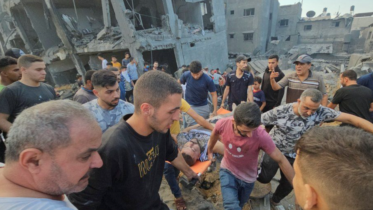
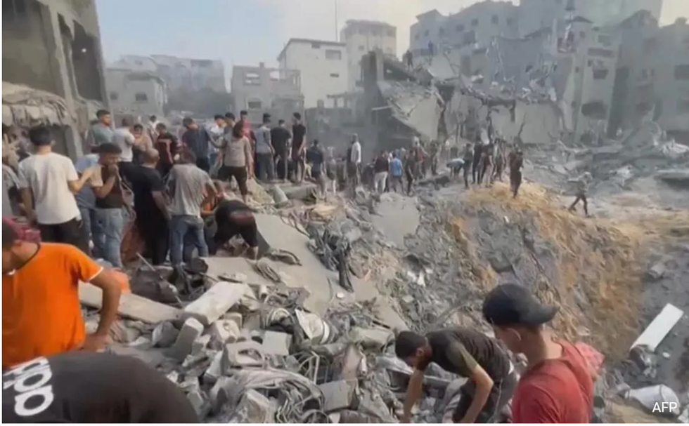
Palestinian survivors searching wreckage of Jabalia refugee camp in northern Gaza on November 1, 2023
We are talking here of the explosion at the Al-Ahli hospital that took place on October 17, and the bombing of a Hamas tunnel complex inside the Jabalia refugee camp in Gaza on Tuesday. Thirty years ago, it would have been impossible to report on such occurrences if you were not a major newspaper or television network with a bureau on the ground in the country where it happened. Twenty years ago, it would have been difficult but not impossible. The internet was there, if not as fast, and there was email, but newspapers and network news shows didn’t have much reporting online, and very few if any videos were posted.
Today, of course, is a very different story. News stories about an event as big as a bombing appear nearly instantaneously. Photos from the scene are up on X (Twitter) and YouTube just as quickly, and so are videos. But what do you do with the stories and the photos and the videos that are available now? That’s what this story is about.
Last night, in the early evening, a story came up from something called “Memo: Middle East Monitor,” which says on its banner they’ve been “Creating new perspectives since 2009 covering Africa, Egypt, Israel, Middle East, News, and Palestine.” They headlined coverage of the Jabalia bombing this way: “Egypt condemns Israeli attack on residential square in Jabalia Refugee Camp.” Here is the photo at the top of the story:
I had read several stories online from the New York Times, Washington Post, and the Associated Press, but nowhere had I seen the site of the bombing described as a “residential square,” which is defined on real estate websites and shows up on maps that identify “squares” like Foley Square and Washington Square, both in New York City, as an open area between buildings in an urban setting.
So, I went to Google Earth and Google Maps, which show maps and aerial images of places around the world differently in subtle ways. Sometimes the resolution of satellite photos is better on Google Earth than it is on Google Maps, sometimes it’s the other way around. And often one or the other will identify the location you’re looking for better than the other. Google Maps, for example, locates the center of Jabalia with a little red squiggle. Google Earth gives you an outline around the blocks covered by the Jabalia refugee camp.
From Google Earth, I could see there are two main areas of the camp. The southwestern part of the camp, where the Jabalia Refugee Camp Market is located, is a jumble of streets and tiny alleys in an area of low, tightly packed structures that look, from overhead at least, like shacks or small cinderblock houses. The area of the camp to the northeast has as its northern border a wide road marked General Beit Lahiya Boulevard, on which the Indonesian Hospital is located. That hospital appears in news stories as “close to” Jabalia, which according to the map, it is.
The northern area of Jabalia is more built up, on a regular grid of paved streets that run between larger buildings that from the satellite photo look like they might be three or four stories. Some of them have what appear to be water tanks on the roof, a common way to distribute water through a multi-story building with multiple apartments in the Middle East. I saw lots of them in Iraq and Afghanistan, for example.
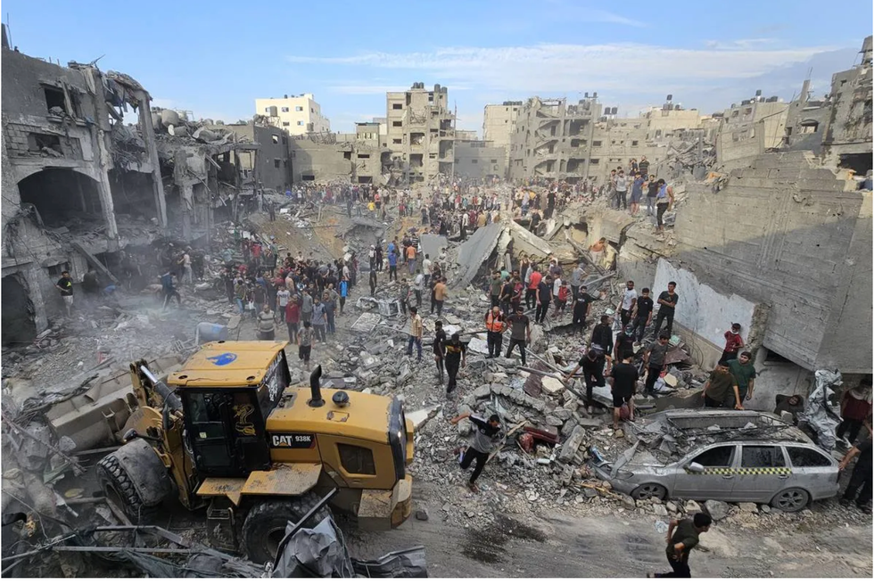
The buildings at the edge of the blast-zone in Jabalia – and I looked at more than 30 photos of them – appear to be three to five stories. You can count the stories from the sides of the buildings that were blown out by the blasts. Several photos, like this one, show three taller buildings in the background that look to be eight stories tall, as shown here:
I started looking on Google Earth for sites that might be described as open areas between buildings, like parks or gathering places or parking lots. There are several of them in the northern area of Jabalia. They show up as tree-filled parks, or dirt lots, or what appear to be paved parking lots.
If you look to the right of the photo, you’ll see a large concrete slab that must be 20 feet across. In the foreground, you’ll see smaller, broken slabs with irregular shapes. They could be slabs of a concrete parking lot that were picked up and thrown away from the center of the crater shown in the photo, which is the largest of four craters that appear in all the different photos.
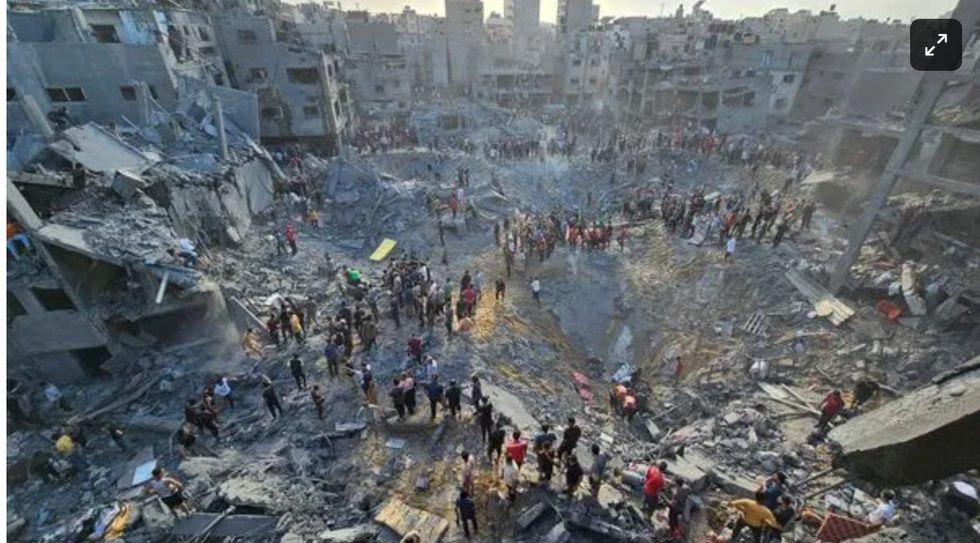
Here is another photo of this crater from further away. The leaning slab appears at the center of the photo:

It looks to me that the vantage point was a street that formed one side of the square. A damaged taxi is parked on the right, and the yellow CAT earthmover in the foreground looks to have driven on level ground to the position where it appears to be pushing debris to the left.
Tracy pointed out that the slabs could have been floors in apartment buildings, and that is possible. It appears that the men at the top right are standing atop the ruin of a building. The slab could have been the roof of that building that fell from left to right as the building collapsed. Looking further, I found a part of a floor from another apartment building. It is in the right center of the photo, the slab with a little square cut out on its left edge.
If you look above and to the left, you can see the building it may have come from: the little cut-out could have fit around the vertical wall shown in the open front of the building. The slab of floor at the center would have fallen down from the building as the front row of the apartments were destroyed by the blast. But the bigger, irregular slab leaning down into the crater at the center of the photo looks more like it was part of a paved area that collapsed when the blast sent material into the air from the center of the crater at the right.
Which brings up the nature of the weapon used in this bombing. Israel has said that the target was a Hamas commander, Ibrahim Biari, whom a spokesman for the Israel Defense Forces described as an architect of the October 7 Hamas attack on Israel. Biari was said to be hiding in a tunnel complex under the Jabalia refugee camp. Israel made use of what appears to be at least three and possibly four bunker-buster bombs in the attack.
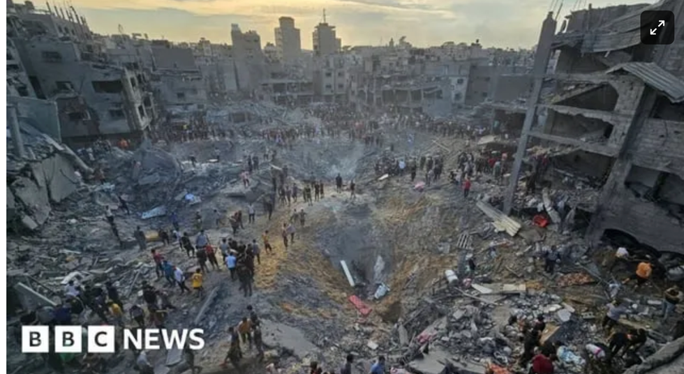
Israel is known to have two types of U.S. supplied bunker buster bombs: The 2,000-pound GBU-31v3, and the 5,000 pound GBU 28, said to have four times the penetrating power of the earlier version they were supplied with. The different types of bunker buster bombs may explain the two sizes of craters. One appears to be 100 feet or more across, and nearly as deep. The other ones are about half as deep and half as wide, as shown in this BBC photo, with the largest crater in the foreground and two more visible in the background:
All of the bunker buster bombs are laser guided, which means they are dropped from a jet aircraft and guided to their target with a laser that “paints” the target from the aircraft. The bomb’s guidance system follows the laser to the target.
The bombs are fitted with a delay fuse, so that the bomb explodes not on impact with a concrete surface, but after it travels through the concrete and into the earth below, so the bomb goes off beneath the surface instead of on top of it. The point of a bunker buster is for the blast to go down and to the side beneath the earth. That’s what destroys bunkers or tunnels. A conventional high explosive warhead on a missile or artillery shell explodes upon impact, and all the blast goes up and out to the sides, producing the kind of craters we have seen in photos of misfired Russian 155 artillery rounds that landed in agricultural fields and left craters about 8 to 10 feet in diameter and about four feet deep.
Some bunker buster bombs have more sophisticated fuses that have accelerometers that can detect delays in the penetration of the warhead and set off the explosion after it has penetrated one or two floors of a building, for example, instead of going off when it first hits a concrete roof. That sort of bomb could have been used in the Jabalia bombing and would have blasted through the concrete floors of apartments before going off when it finally reached the bottom floor and penetrated its concrete slab. Or the bombs could have hit the surface of a parking lot, gone through the concrete and earth, and then exploded several meters below the surface of the earth.
Until and unless an inspection can be made of the site of the bombing, we won’t know whether Israel sent its bombs into what the Middle East Monitor called a residential square, an open area between buildings, or directly into buildings beneath which Israeli intelligence had identified as being above the tunnel they were trying to hit.
This is what you do when you can’t be on the scene. In this case, there has been no reporting from the scene of the explosion that describes the area where the bombs hit. In the case of the Al-Ahli Hospital, we could see that the warhead, whatever it was, and whoever fired it, hit a parking lot and not the hospital itself, and the hospital building was not damaged.
With the Jabalia bombing, we can see the craters left by the bombs, and we can see the damage done to apartment buildings around them, but we cannot know for sure whether the bombs hit a parking lot or directly landed on apartment buildings.
Either way, people were killed. One of them, according to Israel, was the Hamas commander who engineered the massacre on October 7. Other Hamas fighters were killed, too, according to the Israeli spokesman for the IDF. But innocent civilians were also killed in the collateral damage from the bunker buster bombs. Enlarging the satellite photos on Google Earth, I could see cars driving down streets in Jabalia and occasional pedestrians. People live there. They have lives, just like people have lives in Bakhmut and Mariupol and Kherson and Kharkiv in Ukraine, all cities that have been heavily bombed by Russia. And Ukrainians died in those bombings. I remember way back at the beginning of the war in Ukraine covering the bombing of a maternity hospital in Mariupol, publishing photos of a bomb crater in an open area between wings of the hospital. One photo showed a pregnant woman being escorted out of the door to the hospital, gripping her bulging stomach with both hands. She died a few days later.
It is a sad fact of these terrible wars that innocent people die. As I cover these wars from thousands of miles away, going over the photographs of destruction and the maps and the satellite photos and details of the weapons and how they work, one of the hardest jobs I have is remembering the human cost of war. The blood of the dead is the most expensive thing in any war, beyond the physical damage left by bombs and bullets. Please remember that with me.
Lucian K. Truscott IV, a graduate of West Point, has had a 50-year career as a journalist, novelist, and screenwriter. He has covered Watergate, the Stonewall riots, and wars in Lebanon, Iraq, and Afghanistan. He is also the author of five bestselling novels. You can subscribe to his daily columns at luciantruscott.substack.com and follow him on Twitter @LucianKTruscott and on Facebook at Lucian K. Truscott IV.
Please consider subscribing to Lucian Truscott Newsletter, from which this is reprinted with permission.