Goo-Spewing Worm Latest Threat To South Florida

Goo-Spewing Worm Latest Threat To South Florida

By Jenny Staletovich, Miami Herald (TNS)

MIAMI — It has a goo-spewing mouth on its belly, is covered in toxic slime, hosts a brain-eating parasite and, like any ambitious mutant monster, the New Guinea flatworm is invading the U.S. by way of sunny Miami.

There’s also this: the worm is hermaphroditic, so it can multiply anywhere, anytime. No assistance needed.

Researchers last month confirmed for the first time that the Pacific island flatworm has been found on the U.S. mainland in four locations around Miami-Dade County. Even tony Coral Gables. The nocturnal creeper clocks in at just 2 inches, looking more like a smudge of snot than an agile predator. But don’t be fooled by its sluggish demeanor. At mealtime, the worm goes full-on Alien, posing a potentially serious threat to South Florida’s already fragile native snail population.

“It is really vile,” said David Robinson, the nation’s chief snail scientist at the U.S. Department of Agriculture. “As a biologist I can handle most things, but I find this really revolting.”

Scientists worry the worm — which is listed by the International Union for Conservation of Nature as one of the planet’s 100 most invasive species — could spread by being transported in garden soil or on plants.

“From Miami, the flatworm can go anywhere in Florida and anywhere in the U.S.,” said Jean-Lou Justine, lead author of a study published June 23 in the online science journal PeerJ and a researcher at the National Museum of Natural History in Paris.

While humans face little risk from the worm, it thrives on snails and will eat any slug, worm or soft critter living in soil. And its appetite is voracious. Robinson has seen pictures of a Giant African Land Snail — another invasive marauder that is the target of a state eradication campaign — being attacked by a pack of 30 to 40 flatworms.

To get around a snail’s armor, the worm latches onto the shell’s opening, then spits its stomach out through the mouth on its belly. An acidic goo from the stomach dissolves the snail’s flesh so the worm can re-swallow both stomach and prey. Time for dessert.

The worm, native to New Guinea, has now been documented in 22 countries, mostly island nations, making its arrival on the U.S. mainland more alarming, said Justine, speaking to The Herald from Paris.

“In the beginning, we are going to find them mainly in gardens because they will be transported from garden to garden,” he said. “The real problem will be if they go into the wild.”

In his study, Justine said the worm was first reported in the U.S. on Southwest 122nd Street in Miami in June 2012. Four months later, another sighting was reported on Northwest Fifth Avenue. Two years passed before a third worm was reported on Southwest 192nd Terrace.

In August 2014, Makiri Sei, another malacologist — the official title for a snail scientist — was in Miami looking for live tropical snails at the Montgomery Botanical Garden on Old Cutler Road. Sei, who works two offices down from Robinson, was hoping to sequence their genomes as part of a project tracing the evolution of land snails in Jamaica.

Because it had been dry, another biologist suggested she look at night. So at about 4 a.m., Sei headed to a spot in the garden where the day before she had seen empty snail shells. Instead, Sei discovered a slimy flatworm and snapped a few pictures.

“I had no idea what they were,” said Sei, who had been to Florida only once before as a child. Back in Philadelphia, she showed the pictures to Robinson, who suspected Sei had found another flatworm.

While they get little attention, exotic snails and slugs have become an increasing threat with growing global trade. Robinson was hired as the first national malacologist in 1995 and has seen outbreaks of invasive snails threatening wheat crops in Montana, Detroit and Washington state. He has also been working with Florida officials to fight the massive African snails that can grow up to eight inches.

“All through the country we have little outbreaks that come through quarantine barriers,” he said. “They come in on pretty much everything: cut flowers, imported fruits and vegetables.”

While the snails can easily hitch their own rides, Robinson said he also has to battle the food and pet trade intentionally spreading snails. The Giant African Land Snail first reached the U.S. when a Miami boy brought back three from Hawaii as pets and let them loose in his grandmother’s backyard. The snail spread, but after a $1 million effort, they were believed to have been all captured or killed by 1975. They are now back, and have spread into Broward County.

Like the Giant African Land Snail, the New Guinea flatworm carries the rat lung parasite, which burrows into the brain and can spread to humans. In April health officials confirmed one case in Hawaii. Most people suffer muscle aches and sensitivity to light and recover without ever knowing they’ve been infected. But in severe cases, the brain can become infected. The flatworms are also coated in a toxic slime that can cause allergic reactions, so should not be handled.

Justine first documented the worm in France — where any threat to escargot is taken with particular concern — in 2013. Media coverage generated reports of hundreds of other flatworms, but none were confirmed as New Guinea, meaning they had not ventured beyond gardens and into the wild.

The worms have devastated snail populations in Guam and on the Mariana Islands, Robinson said, but not in Hawaii, possibly because native snails live in the highlands on Oahu and the Big Island. Populations of invasive snails in lowlands also appear unharmed, he said.

“In the case of Florida, we don’t really have a handle on what it could do,” he said, but pointed out that even after several years it does not appear to have had a significant impact.

“We can hope that Miami is not the best place for it to survive,” he said.

But should they spread, South Florida’s native snail population, already imperiled by shrinking habitat and threatened by climate change, collectors and invasive fire ants, could be in trouble.

“They are nowhere else to be found,” Sei said. “So once they are gone from South Florida, they are gone from the whole world.”

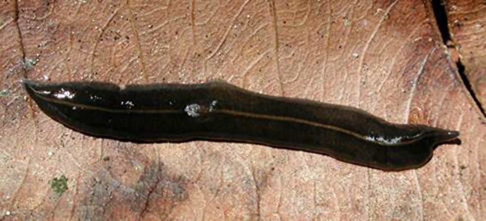
Photo: National Malacologist David Robinson photographed this New Guinea flatorm in Guam. The predatory worms consume native snails, carry rat lung worm and are coated in a slime that can cause allergic reactions. (David Robinson/TNS)

United Way Study Finds Working Families Struggling To Get By

United Way Study Finds Working Families Struggling To Get By

By Jenny Staletovich, Miami Herald (MCT)

MIAMI — Almost half the residents of Florida, including much of the state’s glitzy southern half, are barely getting by, living below the federal poverty level or struggling to pay for food, housing, childcare and other basic needs, according to a United Way study released Tuesday.

Dubbed the ALICE report, the study looks closely at the working poor — those people squeezed between the nation’s poorest and its middle class, often overlooked and living paycheck-to-paycheck. Statewide, about 2.1 million households fall into the category, the report found. In Miami-Dade County, the rate is even higher: 21 percent of households live below the federal poverty level and an additional 29 percent can’t afford a “survival budget.”

In Broward and Monroe counties, the numbers are almost as bleak, with 47 and 48 percent living below the poverty level or scrambling to cover basic needs, according to the report.

“This is struggling day to day just to be able to have an education, access to health care, transportation and childcare,” said Maria C. Alonso, a United Way Miami-Dade board member and co-chair of the group’s Community Impact Committee. “It is an eye-opener.”

To come up with a formula to define the working poor, researchers from the School of Public Affairs and Administration at Rutgers University-Newark calculated the actual cost of living in disparate communities in Florida and five other states. They then devised a “survival budget,” or the amount needed to cover basics, and layered them with statistics on housing costs, wages and other indicators to reach their findings.

The study is the second effort by the Rutgers team to look at poverty. In 2009, the United Way conducted a pilot project in New Jersey and found it so effective at communicating poverty needs that it expanded the study to five other states, including Florida.

But defining poverty can be tricky. Economists have long wrestled with how to better measure the financial struggles of the nation’s poor. Since the federal government developed official Federal Poverty Level guidelines in 1965, it has updated the methods for calculating measures only once — in 1974 — leading some agencies to multiply the federal poverty rate or come up with other factors.

“Poverty is both an absolute and a relative measure,” explained University of Miami economist Philip K. Robins.

Measures can vary greatly, he explained. High housing costs in South Florida and the Keys could mean trouble for a middle-class Jacksonville family. Regional efforts also have to be factored in: What kind of tax breaks are available? Is there enough free preschool? Did the state expand Medicaid coverage under the Affordable Care Act?

Robins said he suspected the numbers are too high and might not factor in all government subsidies.

“What you mean by ‘getting by’ varies from person to person,” he said. “To say half the households are struggling to afford basic necessities, I’m not sure that jibes with reality.”

In Monroe County, housing costs and a shortage of affordable child care have created a perfect storm, said Margie Smith, president of the United Way of the Florida Keys. The county has a lower poverty rate than most — just 12 percent. But the number of households struggling to make ends meet under the study’s parameters is higher, 36 percent.

“It’s easy to live here and be in a beautiful place and have no idea what your neighbors are struggling with,” Smith said. The report provides a way for the larger community to look at “the struggles of our neighbors and how much of our economy has become fragile.”

For their survival budgets, Rutgers researchers determined that a family of four in Florida would need $47,484 a year and a single adult would need $18,624 — or about twice the federal poverty rate. The survival budget varies depending on location: For a family of four in the Keys, it is $61,962. Survival budgets include costs for housing, childcare, food, health care and transportation. Researchers then added up the number of households they considered ALICE families, or Asset Limited, Income Constrained, Employed.

They attribute the swelling ranks of the poor to a variety of reasons.

More than half of the jobs in Florida pay less than $15 an hour, with the greatest growth in the job market projected for low-paying retail and service industry jobs. Almost half of households — 48 percent — don’t have enough savings or liquid assets to survive three months without a paycheck. And the state’s aging population means even more residents are likely to slip into poverty.

The state’s demographics don’t offer much hope: Only 27 percent of residents older than 25 hold a bachelor’s or advanced degree.

In 2011, Alicia Smith, 33, found herself teetering on the edge. She was deep in debt, jobless and trying to raise three daughters. Then one day she saw a flier for a United Way program near her house, dropped by and signed up for financial counseling.

Within a year, Smith had her credit under control. A United Way counselor also helped her pull together her resume, which led to a job as a mall security guard. Now she plans to complete the degree in criminal justice she started before her money troubles set in, and is applying for loans to buy a house.

“I don’t have to worry about collection calls. I have good credit. I got a job. I’m independent,” she said. “I don’t have to look back on anybody to help me. My girls are doing well in school, and my life is normal. It’s not perfect, but it’s better than before.”

Smith’s household is exactly the kind that the ALICE report hopes to highlight, United Way officials said. The agency plans to use the study’s findings to inform programs and tailor lobbying efforts during the spring legislative session in Tallahassee. The state’s 32 United Way chapters have agreed to focus on three areas that directly affect working poor households: access to early education; financial education and free tax preparation; and affordable health care coverage, said spokeswoman Yanet Obarrio Sanchez.

“We often focus on families in poverty and what their needs are and what the social safety net looks like,” said Brittany Birken, CEO of the Florida Children’s Council. “But this gives us good information, that there is another tier that warrants attention as well. … These are families that are economically self-sufficient, who are working hard and making ends meet, but they’re pretty close to the edge and living paycheck-to-paycheck.”

Alice Smith, center in black shirt, cleans up lunch with her daughters Jakira, right, Asia, center, and Shanteria Nov. 11, 2014 in Miami. The Smiths are one of the working fmailies highlighted by a new United Way study that looks closely at the struggles of the working poor. (Peter Andrew Bosch/Miami Herald/MCT)

Storm Predicted To Become Tropical Depression But Miss U.S. Coast

Storm Predicted To Become Tropical Depression But Miss U.S. Coast

By Jenny Staletovich, The Miami Herald

MIAMI — A storm system cruising across the Atlantic and dumping heavy rain is expected to become a tropical depression over the weekend.

The system, clumsily making its way west as a sloppy wet system, has gradually drifted northwest, prompting most tracking models to point it away from the U.S. coast. Forecasters with the National Hurricane Center said early Friday it is expected to sideswipe Haiti and the Dominican Republic by nightfall. The island, already soaked by the wet season, could get heavy rain.

The island’s mountains will likely keep the storm disorganized, forecasters predicted. But they expect warm waters and other conditions in the Caribbean to feed the storm as it moves over the southeastern Bahamas on Saturday.

Earlier this month, National Oceanic and Atmospheric Administration forecasters updated their seasonal outlook, predicting the season would fall well below average.

They predicted just five to 10 storms over the rest of the season, which runs through November. Counting Arthur and Bertha — two hurricanes that arrived early in July and August — only one to four more hurricanes are forecast. The prediction for the number of major storms with winds topping 110 mph stands at up to two.

If the depression grows to a tropical storm, it would be named Cristobal, the third named storm of the season.

Photo via WikiCommons

Interested in world news? Sign up for our daily email newsletter!

Fewer Hurricanes Predicted In Updated Forecast

Fewer Hurricanes Predicted In Updated Forecast

By Jenny Staletovich, The Miami Herald

Forecasters upped the odds for a slow hurricane season Thursday, predicting even fewer storms as record strong winds in the upper atmosphere keep a lid on brewing storms.

Just five to 10 storms are predicted over the rest of the season that runs through November, said Gerry Bell, lead hurricane forecaster for the National Oceanic and Atmospheric Administration. Counting Arthur and Bertha — two hurricanes that arrived early in July and August — only one to four more hurricanes are forecast. The prediction for the number of major storms with winds topping 110 mph still stands at up to two.

“But that doesn’t mean the season is over,” Bell said. “Four hurricanes is a fair amount and all it takes is one of those to make landfall.”

In May, forecasters predicted eight to 13 named storms, three to six hurricanes, and one to two major hurricanes. They initially believed that an El Nino weather pattern would develop over warming Pacific waters and keep the season in relative check. They also forecast a slow monsoon season off West Africa, in addition to strong winds in the upper atmosphere.

As it turns out, the El Nino pattern has wilted and is now less likely to form during the Atlantic hurricane season. But the record upper winds and weak monsoon conditions appear to be enough to tamp down the season, Bell said. Tropical waters in the Atlantic that feed storms have also remained cooler than expected.

“They’re in place independent of El Nino,” he explained.

Upper atmosphere winds play a crucial role because they make it difficult for storms to grow in strength. Finding out what produced this year’s persistent pattern will take more study, he said, particularly if it relates to climate change.

Since 1981, an average hurricane season has produced 12 named storms, with six hurricanes and three major storms. For the last eight years, Florida — which has been hit more than any other state — has been struck by just one major storm despite more than 1,200 miles of coastline that open it up to storms from almost every direction.

While welcome, this week’s improved forecast should not be taken as a free pass for the season, Bell warned. Forecasters still can’t say in advance what direction storms may take and even one can make life miserable. Take Arthur, which turned the Fourth of July holiday into a frustrating evacuation for much of the Outer Banks when it struck as a Category 2 on July 3.

“There’s no way to predict so far in advance where a hurricane is going to strike,” Bell said. “Even a slow moving tropical storm can dump a foot of rain.”

AFP Photo

Interested in world news? Sign up for our daily email newsletter!

Arthur Grows Into A Hurricane, Headed Toward Carolinas

Arthur Grows Into A Hurricane, Headed Toward Carolinas

By Jenny Staletovich, The Miami Herald

MIAMI — Arthur became the season’s first hurricane early Thursday, headed toward the Carolinas after forming as a meandering tropical depression off the steamy coast of Florida earlier this week.

The storm, with 75 mph winds, struggled to maintain its eye overnight but should continue to intensify as it bears down on the coast, likely moving perilously close to the Outer Banks by Thursday night or early Friday, the National Hurricane Center reported.

Hurricane warnings were issued for much of North Carolina’s coast. A hurricane watch also extended just over the state line into South Carolina.

While Arthur barely affected South Florida, bands of rain and thunderstorms lashed the area early in the week. With the most persistent storms trailing Arthur’s south side, some thunderstorms may have packed 50 mph wind gusts, the National Weather Service said. The messy weather should clear out Thursday, with normal afternoon storms and showers resuming just in time for the holiday weekend.

Holiday and weekend storms should be primarily inland, said National Weather Service meteorologist Chuck Caracozza.

As the storm, with hurricane winds extending 25 miles from its center and tropical storm winds reaching 90 miles, cruises north into the Carolinas, a combination of storm surge and high tide may trigger coastal flooding. If the surge rides a high tide, flooding in parts of Florida’s coast near Fernandina Beach could reach three feet. Isolated spots near Amelia Island may have had more.

In North Carolina, areas could get as much as two to four feet of water, accompanied by damaging waves, forecasters said. Flooding may reach one to three feet in parts of South Carolina and one to two feet in southern Virginia. Rip currents will also follow the storm north.

Fourth of July holiday plans were interrupted for much of North Carolina, where the state’s governor placed coastal counties under a state of emergency. A mandatory evacuation was issued for Hatteras Island.

Forecasters are keeping a careful eye on Arthur’s track because even a slight turn, coupled with a growing wind field, could expand the range of hurricane winds.

Arthur also picked up speed slightly overnight, increasing to about 9 mph. Moving over colder water faster could keep the storm from gaining strength, hurricane center spokesman Dennis Feltgen said.

“It’s a good thing in that it won’t be hanging around,” he said. “So this thing won’t be grinding away along the coastline.”

On Friday, west winds carried by a northerly jet stream should drive Arthur away from shore off the coast of New England and up into Canadian waters by Saturday.

AFP Photo

Interested in national news? Sign up for our daily email newsletter!

Arthur Gains Strength, Likely To Become Season’s First Hurricane

Arthur Gains Strength, Likely To Become Season’s First Hurricane

By Jenny Staletovich, The Miami Herald

MIAMI — Tropical Storm Arthur continued to gain strength Wednesday as it trudged along the central coast of Florida and is likely to become the season’s first Atlantic hurricane Thursday.
The slow-moving storm with tropical-force winds extending about 80 miles from its center was headed north after briefly moving south on Monday, when it formed. Forecasters with the National Hurricane Center expect Arthur to head past the northeast corner of Florida sometime Wednesday, before turning toward the Carolinas.

At 8 a.m. EDT Wednesday, the storm was 100 miles off Cape Canaveral and moving away from Florida at 6 mph. A hurricane watch was issued for part of North Carolina’s coast early Wednesday as Tropical Storm Arthur moved northward, threatening Fourth of July plans along the East Coast. A tropical storm watch remains in effect from Sebastian Inlet to Flagler Beach in Florida.

A Hurricane Hunter plane, sent to investigate the storm Tuesday afternoon, measured sustained winds of 50 mph with higher gusts. The crew reported being “bounced around pretty good by strong thunderstorms,” before taking refuge at a higher altitude.

Maximum winds were up to 60 mph on Wednesday morning.

“We’re now urging folks on the coast to monitor the situation because a lot of people have beach plans for the holiday, so they need to be watching this real close,” said National Hurricane Center spokesman Dennis Feltgen.

AFP Photo

Interested in national news? Sign up for our daily email newsletter!

First Tropical Storm Of Season, Arthur, Slogging Off Florida Coast

First Tropical Storm Of Season, Arthur, Slogging Off Florida Coast

By Jenny Staletovich, The Miami Herald

MIAMI — The season’s first tropical depression blossomed into Tropical Storm Arthur on Tuesday as it slogged north along the coast of Central Florida.

The storm, with tropical force winds extending about 45 miles, was headed northwest at 2 mph and could strengthen into the season’s first Atlantic hurricane later Thursday when it reaches the Carolinas, said National Hurricane Center spokesman Dennis Feltgen.

Forecasters expect the storm to remain offshore as it continues north and turns to the east later Tuesday or Wednesday.

“We’re now urging folks on the coast to monitor the situation because a lot of people have beach plans for the holiday, so they need to be watching this real close,” Feltgen said.

The slow-moving storm triggered a tropical storm watch for the state’s east coast, from Fort Pierce to Flagler Beach.

As it trudges north, South Florida can expect even more rain from Arthur’s lingering tail, forecasters said. The wet system may dump one to three inches of rain along the east coast, with some spots receiving as much as five inches. The northwestern Bahamas could see two to four inches, with as much as six inches in some areas.

The rain that soaked the area Monday should continue Tuesday as winds from the east and west collide to spark more rain, said National Weather Service meteorologist Dave Ross. On Monday, parts of Miami Beach received as much as 3.5 inches. The Doral area also topped three inches, but Miami International Airport received less than two inches.

“It can really vary,” Ross said. “Two to four is not out of the question, but you can see higher amounts.”

Bands from the storm should continue to feed rain Tuesday and Wednesday, but by Thursday clouds are expected to clear out with the chance of rain dropping to about 20 percent, he said.

If Arthur strengthens to a hurricane, it will become the first storm in a season that forecasters with the National Oceanic and Atmospheric Administration project to be slow. Just eight to 13 tropical storms are forecast, with three to six growing into hurricanes and two becoming major storms packing winds over 111 mph. On average, 12 named storms form, with six turning into hurricanes and three strengthening to major storms.

While no hurricanes have struck Florida in eight years, there have been near misses, including Dorian, which made a beeline for Florida last July before turning north.

Photo via NASA’s Marshall Space Flight Center

Interested in national news? Sign up for our daily email newsletter!